California, also known as California in English, is located in the west of the United States of America, the West Coast, on the Pacific Ocean. It borders Arizona, Baja California in Mexico, Nevada and Oregon. California got its nickname Golden State during the gold rush in the middle of the 19th century, where the precious metal was found.
The West Coast State of California
Golden Gate Bridge in San Francisco, California
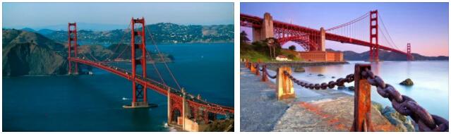
This is how the Golden Gate Bridge in San Francisco got its name.
With a click on the thumbnail, the photo of the Golden Gate can be displayed in a larger format.
Even today, thanks to the high price of gold, the rivers of California are still being washed diligently.
And that also in the then already popular places around Coloma or Jamestown. Some smaller finds keep inviting new fortune-seekers, who then live quite simply, for example in a caravan near the mining sites.
With a size of almost 424,000 square meters, California is the third largest state in the alliance after Alaska and Texas. This means that California alone is larger than Germany, for example, which measures around 357,000 square meters. In terms of population, however, it is considerably behind Germany. With a good 37 million inhabitants, California is less than half as populated as Germany, for example, with its more than 81.8 million citizens.
I used to think that the capital of California should actually be Los Angeles or San Francisco because of its size and popularity. Then, however, I was surprised to read on Wikipedia that this is Sacramento. Located 120 kilometers from the Pacific Ocean, the city is in northern California in Sacramento County.
Geography of California
San Andreas Trench
California lies on the San Andreas Fault, which is why earthquakes are common throughout the region. This is where the Pacific meets the North American plate, which runs 1,100 kilometers from Mexico to San Francisco.
The rift basically divides the state of California in two. San Francisco is on the North American Plate and Los Angeles on the Pacific Plate.
Mount Whitney, at 4,418 meters, is the highest mountain in the United States (outside Alaska) in California. Death Valley, the valley of death with the lowest point in the USA is about 100km away: Badwater is the name of the place and it is 85.5 meters below sea level. Death Valley got its name from the time of the first West Coast settlers, who endured agony of heat and thirst when traversing Death Valley. There are also some nature parks in California. Yosemite National Park is one of the most well-known here.
As noted above, California is a fairly sprawling state.
On a journey from the north to the south border, at least 1,300 km have to be overcome.
To get an idea of the routes, here are some typical distances for tourist routes in California :
From San Diego to Los Angeles (LA) it is about 200km. From LA to Las Vegas in the state of Nevada you have to reckon with a distance of about 430km.
It’s about 400 miles from Los Angeles to San Francisco. From there to Yosemite National Park it is another 300 km.
On the west coast you can get by with any vehicle. With a rental car, motorcycle or camper you can easily get around here, there are enough rental companies, so that the prices are often quite cheap. In the high season in California, in summer, booking in advance is of course recommended.
Climate and weather
The weather in San Francisco (Frisco) is quite pleasant in the summer, up to 25 degrees around. It gets really hot in southern California, towards the Mexican border. However, even in summer Frisco is often visited by heavy fog, especially in the morning. Here you can take great shots of the city in the fog from elevated points. Otherwise, it does rain in Frisco in the summer.
The weather on the other side of the Golden Gate is often completely different, i.e. the sun is shining. That’s why you should definitely have a look there if you’re there and want to take photos.
In Los Angeles it is already hot in the summer and the mercury rises above 30 degrees Celsius. But when the Pacific breeze blows into the city, it’s bearable. Even in winter it doesn’t get too cold in LA, around 10 degrees at night is the extreme in the lower temperature range. What is striking, however, is that in winter the sun goes to sleep quite early, around five in the evening from November to January it is already getting dark.
For us, the best time to travel to California is from the end of March to the end of May and the beginning of September to the end of October. Between Memorial Day (last Monday in May) and Labor Day (first Monday in September), Americans themselves travel a lot.