New Mexico is a state in the southwestern United States. The name comes from the Spanish conquerors who used it to designate the land west and north of the Rio Grande.
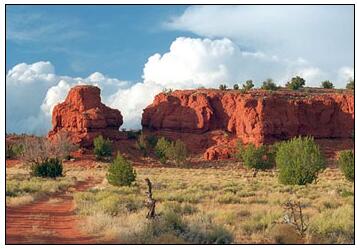
The wealth of landforms, the clear air with the mostly blue sky and the varied colorful rocks are characteristic of New Mexico. New Mexico (abbreviated NM) is therefore also called the Land of Enchantment (Tierra de Encanto).
| Area | 314,915 km² |
| Residents | 2,081,015 |
| Residents per km² | 6.6 |
| Capital | Santa Fe |
| Postal Code | NM |
| ISO-3166-2 code | US NM |
| FIPS code | 35 |
Geography
With an area of 314,915 km², New Mexico ranks fifth among the 50 US states. Only Alaska, Texas, California and Montana are bigger. This makes New Mexico about the size of Poland.
New Mexico extends from the 31st to 37th parallel north (maximum north-south distance ~ 630 km) and from 103rd to 109th western longitude (mean east-west distance ~ 553 km).
Neighboring states
Abbreviated as NM by AbbreviationFinder, New Mexico borders Colorado to the north, Oklahoma to the northeast, Texas to the east and south and Arizona to the west. At Utah New Mexico borders only at a single point in the northwest, the so-called Four Corners. The state border with Mexico forms part of New Mexico’s southern border.
National nature
All of New Mexico is characterized by its location on a plateau. However, this is not uniform, but the transition area of four geological provinces in North America. From the east the terrain rises flat out of the high plains prairies.
The southwest of the state is part of the Chihuahua Desert, which is part of the Basin and Range Province.
From the northwest the Colorado Plateau rises to New Mexico and in the north the Sangre de Cristo Range extends the southernmost parts of the Rocky Mountains to Santa Fe.
The major parts of the country on the leeward side (Lee) of the Rocky Mountains are arid. The drought characterizes the landscape in the plains as in the mountains. Exceptions are the mountains north of Santa Fe and the area to the west beyond the continental divide, where there are extensive forests. In the mountains north of Santa Fe, the amount of precipitation in winter is so great that a winter sports region has emerged there. There are also areas that are almost untouched by humans, such as the Gila Wilderness in the southwest. The highest mountain is Wheeler Peak north of Santa Fe at 4,011 m.
Rivers and lakes
The most important river is the Rio Grande. It rises in Colorado and flows through New Mexico from north to south, past Albuquerque and Las Cruces – mostly accompanied by Interstate Highway 25. From Texas, the Rio Grande forms the border with Mexico and flows into the Gulf of Mexico after 2,896 km. The Rio Grande is a real lifeline for agriculture, but it is also important for the energy industry.
The Rio Pecos and the Canadian River are also important rivers. The Rio Pecos also flows north to south, irrigating the southeast from Roswell via Artesia and Carlsbad to the Texas border. The Canadian River flows through northeast New Mexico and then over the “Panhandle” from Texas until it flows into Arkansas in eastern Oklahoma. The Canadian River, however, only gains importance in Texas and Oklahoma.
Because of the mainly dry climate, there are only insignificant natural lakes; of the artificial reservoirs is the Elephant Butte the most important.
Climate
Because of its southern location and the fact that it is on the leeward side (Lee is) the Rocky Mountains, the climate of New Mexico is consistently dry and very very very hot in summer. In winter, however, due to the altitude, it can also get frosty cold, especially in the north, where there is a real winter sports area in the mountains north of Santa Fe.
History
Long before Europeans explored the area, the area was inhabited by Indian tribes. They settled on rivers and in the hinterland. Probably the oldest continuously inhabited settlement in the United States is Taos Pueblo in the north of the state. Significant cultures, including the Anasazi and Chaco cultures, emerged in the southwestern part of what is now the United States between about AD 1000 and 1300. These cultures ended in the 13th / 14th centuries, probably due to changes in climatic conditions. Century.
When in 1540 the Spanish conqueror Francisco Vásquez de Coronado lived there Pueblo Indians, especially Hopi and Zuñi. When the Spanish conqueror Francisco Vásquez de Coronado crossed the country in 1540, Pueblo Indians lived there, especially Hopi and Zuñi. Spanish missionaries and settlers followed the conquerors. As a result, there were repeated clashes between the Indians and the immigrants.
Despite trade between whites and Indians, there were repeated armed conflicts, and it was not until 1780 that the first peace agreement was reached between the Indians and Spaniards. New Mexico was under Spanish rule until 1821, then under Mexican rule until 1846.
In 1848 New Mexico fell to the United States with the Guadalupe-Hidalgo Treaty. In 1853 the southernmost part of the state was acquired by Mexico with the Gadsden Purchase. Nine years later, New Mexico was briefly under the Confederate government, which, however, had to surrender the area to the Union after the Battle of Glorieta Pass.
After the Civil War, ranching became one of the most important economic drivers in New Mexico. Clashes between the cattle barons and the government culminated in a regular war that went down in history as the Lincoln County Cattle War.
In addition, the construction of the Santa Fe Atchison, Topeka and Santa Fe Railway in the 1880s and the discovery of oil in the late 19th century resulted in rapid growth in the area. Finally, on January 6, 1912, New Mexico became the 47th state in the United States.
After the development of the atomic bomb as part of the Manhattan Project in Los Alamos, the first nuclear weapon explosion in history, the Trinity Test, took place on July 16, 1945 at the Alamogordo test site, 280 km south of Albuquerque.
Economy
The real gross domestic product per capita (English per capita real GDP) was 44,832 US dollars in 2016 (national average of the 50 US states: 57,118 US dollars; national ranking: 40).
The unemployment rate was 6.1% in November 2017 (national average: 4.1%), making it the third highest of all states.
Agriculture (corn, wheat, millet, cotton) is only possible with artificial irrigation. Livestock is important. Oil, natural gas and potash salts, among others, are promoted in New Mexico.
Main industrial products include: chemical products, food, machinery, metal goods and wood products.
The US government operates two nuclear research and development centers in New Mexico through the Department of Energy (DOE) : Sandia National Laboratories in Albuquerque and Los Alamos National Laboratory in Los Alamo s. The United States’ only active nuclear waste disposal facility is also located in New Mexico.
Also known as Land of Enchantment, New Mexico is short for NM with a population of 1,819,046. According to Countryaah, the capital city of New Mexico is Santa Fe and the biggest city is Albuquerque.