| New York State Route 987C | |||
| Get started | Fort Lee | ||
| End | Montgomery | ||
| Length | 39 mi | ||
| Length | 62 km | ||
|
|||
According to citypopulationreview.com, the Palisades Interstate Parkway (PIP) is a parkway in the U.S. states of New Jersey and New York. The highway is named after the Palisades, a line of cliffs on the west bank of the Hudson River. The highway runs in the New York metropolitan area. The highway begins at the George Washington Bridge in Fort Lee, New Jersey and runs to Fort Montgomery in New York. Most of the route passes through suburbs, and the entire length is 62 kilometers.
Travel directions
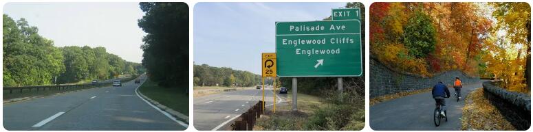
The highway begins at the George Washington Bridge, which connects New Jersey to New York. The highway runs along very steep cliffs, rising 100 meters above the Hudson River. There are 2×2 lanes available. The skyline of Manhattan can be observed from the parking lots. There is only 140 meters as the crow flies between some exits and the Hudson, but with a height difference of more than 100 meters. The highway runs largely through the Palisades Park of the same name. Opposite Yonkers and the northern suburbs, the abyss right next to the highway slopes down almost perpendicularly. At Rockleigh one crosses the border with New York. One comes here in Rockland County, a fairly sparsely built suburban county. At Nanuet one crosses Interstate 87, which runs from New York to Montreal. The road is scenically beautiful, with lots of forest. After Mount Ivy the landscape becomes more hilly, and the road climbs to about 230 meters. At Fort Montgomery, the highway ends at a roundabout with US 9W.
History
In 1900, the Palisades Interstate Park Commission was formed to protect the scenic Palisades cliffs from urban development and mining. The park was 20 miles long between Fort Lee and Piedmont. Access to the park was poor at first, only via ferries and poor local roads. In 1903, Henry Hudson Drive, a rustic long road overlooking the Hudson River, was proposed. This was the predecessor of later proposals for a parkway. The road eventually opened as the Henry Hudson Drive between 1921 and 1926. This was a 7-foot-wide 12-mile road in the New Jersey section.
In 1928 a major plan was presented for the construction of highways in and around New York City. The Parkways were intended both for a limited amount of commuters, but mainly for recreational purposes. In 1931, the George Washington Bridge opened, triggering strong suburban growth in New Jersey. The Palisades Parkway was planned in 1933 and 1934, with an estimated cost of $25 to $40 million to obtain a right-of-way. However, it wasn’t until 1946 that the parkway was approved by New Jersey and New York legislation. With nearly 30 years of knowledge of parkway building, construction of the Palisades Interstate Parkway began on April 1, 1947. The highway was completed in phases in the late 1940s and 1950s. However, construction was delayed due to shortage of materials caused by the Second World War and the Korean War. The last section opened in New Jersey at Alpine on June 22, 1957. A year later, on August 28, 1958, the last 5 miles between Tappan and I-87 were completed. The cost ended up being $47 million.
Traffic intensities
In New Jersey, there are about 60,000 vehicles per day, in New York up to 84,000 vehicles, which decreases to 35,000 in the northern part.
| Exit | Location | 2008 |
| 1 | Fort Lee | 45,000 |
| 2 | Tenafly | 43,000 |
| 4 | alpine | 59,000 |
| 5 | NY-303 | 52,000 |
| 6 | Veterans Memorial Road | 58,000 |
| 7 | Town Line Road | 58,000 |
| 8 | NY-59 | 72,000 |
| 9 | 83,000 | |
| 10 | Middletown Road | 72,000 |
| 11 | New Hempstead Road | 54,000 |
| 12 | NY-45 | 62,000 |
| 13 | 57,000 | |
| 14 | Willow Grove Road | 44,000 |
| 15 | Stony Point Road | 39,000 |
| 16 | Welch Parkway | 29,000 |
| 17 | Wayne Recreational Area | 31,000 |
Lane Configuration
| From | Unpleasant | Lanes |
| Exit 0 (I-95) | Exit 20 | 2×2 |