The vast landscape of Nevada has its own special charm
The US state of Nevada is located in the western part of the United States. The name comes from Spanish, where “nieve” means “snow”. Nevada has the nickname “Silver State” thanks to its rich silver deposits. There are also large gold deposits in this otherwise rather barren desert state. The state has a little over 2.7 million residents.
Experience the US state of Nevada!
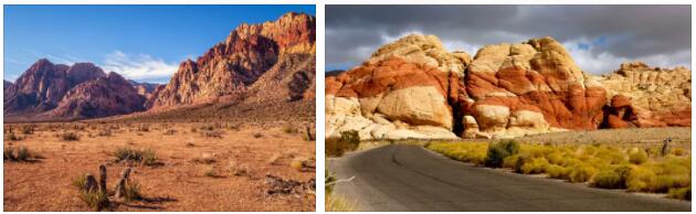
Red Rock Canyon in Nevada
The neighboring states are California, Oregon, Idaho, Utah and Arizona. Large parts of Nevada are restricted military areas, particularly the Nellis Range in the south of the state. Covering large parts of the Nellis Range, about 100 miles north of Las Vegas, the former Nevada Test Site was the site of most of the surface and underground American nuclear bomb testing during the Cold War era.
There are also facilities for testing secret military missiles, such as the legendary Area 51.
Otherwise, Nevada’s sights are certainly known at least from hearsay: The Grand Canyon National Park, the Hoover Dam and the gambling city of Las Vegas can be found in the desert state of Nevada, among other things.
Myth Nevada Triangle
Why do planes crash over the Sierra Nevada? Scientists estimate that around 2,000 planes disappeared in the so-called ‘Nevada Triangle’ between Las Vegas, Fresno and Reno. The most famous plane crash in the region is that of millionaire adventurer Steve Fosset. His plane disappeared without a trace over the American mountain range in 2007. His remains were found almost a year later.
The biggest cities
Fun in Las Vegas on the Strip
The population figures of the largest cities are rounded, the figures come from the year 2010, so that deviations from the last available data are normal and to be expected.
1st Las Vegas 584,000
2nd Henderson 258,000
3rd Reno 225,000
4th North Las Vegas 217,000
5th Sparks 90,000
The capital, Carson City
The capital is Carson City, about 55,000 residents live there.
In 1859, the discovery of gold and silver at Comstock Lode (below present-day Virginia City) sparked a growth spurt in the region. Due to rapid population growth, Nevada was separated from Utah Territory in 1861. At that time, Carson City prevailed against its competitors Virginia City and American Flat as the capital. Carson City became known in the German-speaking world primarily through Mark Twain, who lived here with his brother in the 1960s.
Las Vegas
Las Vegas is the largest city in the US state of Nevada. It is best known for its large number of casinos, which have settled along the Las Vegas Strip, among other places. The population of 340 square kilometers is 613,599 (2014), the agglomeration spreads out over 1200 square kilometers and has a total of almost two million inhabitants. Las Vegas is the county seat of Clark County. The name comes from Spanish and means “The meadows” or “The meadows”. Las Vegas is a globally important tourist center, with around 40 million tourists traveling to it every year.
In addition to the casinos, the shows shape the public character of the city. Artists working in Las Vegas have included and include musicians such as Elvis Presley, The Rat Pack with Frank Sinatra, Sammy Davis Jr. and Dean Martin, Celine Dion, Johnny Cash, Elton John and illusionists such as Siegfried and Roy, David Copperfield, Criss Angel or the Cirque du Soleil. The city is also known for its large number of wedding chapels, as Nevada has uncomplicated marriage and divorce laws.
Henderson
With over 270,000 inhabitants (2011), Henderson is the second largest city in the US state of Nevada. It is located in Clark County, about 20 kilometers south of Las Vegas and has an area of 206.4 km². The population density is 1125 inhabitants/km². Henderson is home to Nevada State College. The city was formed in the 1940s and was named after US Senator Charles B. Henderson. Henderson’s most famous resident was film legend Tony Curtis, who lived here from 1998 until his death in 2010.
Reno
Reno is the third largest city in the US state of Nevada. The Reno region includes Washoe County with a total population of about 420,000, including 225,000 in the city itself. Reno is 4,000 feet (1,371 m) above sea level in the valley of the Truckee River on the western edge of the Great Basin at the foot of the ascent to and near the Sierra Nevada the California border. To the northeast is the borough of Sparks, forming a single urban agglomeration with Reno.
North Las Vegas
North Las Vegas is a city in Clark County, Nevada, United States. The city is located directly in the Las Vegas metropolitan area and is therefore part of the Las Vegas metropolitan area, which is home to almost 2 million people. North Las Vegas, like Las Vegas itself, is currently one of the fastest growing major cities in the United States. North Las Vegas’ population has more than quintupled since 1980. The city is also home to Nellis Air Force Base and North Las Vegas Airport.
Sparks
Sparks is a borough in Washoe County, Nevada, United States, with a population of approximately 90,000. Sparks is located on the Truckee River near the California border. The Great Basin stretches to the east, and the Sierra Nevada mountain range begins to the west. Together with Reno to the southwest, the municipality forms a single urban agglomeration.
Nevada’s rivers and lakes
The longest rivers in Nevada
The Colorado River
The Hoover Dam dams the Colorado River near Las Vegas
The Colorado (Spanish for colored red) is the largest and most important river in southwestern North America. He is 2333 kmlong and has a water catchment area of 635,000 km². Agriculture, drinking water, and electricity supplies in the southwestern United States and parts of California depend heavily on the water regime of the Colorado River. To this end, a large number of irrigation projects of various sizes were built between the end of the 19th century and the 1980s. The river originates in Rocky Mountain National Park in the US state of Colorado and flows from the mountains of the Rocky Mountains into Utah and Arizona, forming most of the Arizona-Nevada border. The Colorado then flows into Mexico and empties into the Gulf of California between the states of Baja California and Sonora.
There are several massive dams along the river, such as the Hoover Dam, which dams Lake Mead near Las Vegas, Nevada, and the Glen Canyon Dam on Lake Powell. The reservoirs are drinking water reservoirs and are used to generate electricity.
Owyhee River
The Owyhee River is a left tributary of the Snake River in northern Nevada, southwestern Idaho, and southeastern Oregon. The river has a length of 557 km. The Owyhee River catchment area covers 28,617 km². The Owyhee River drains a remote sparsely populated area located on an arid plateau on the northern rim of the Great Basin. It originates in northeastern Nevada, from where it flows in a mostly northerly direction toward the Oregon-Idaho border and reaches the Snake River. The Owyhee and its tributaries cut through the Owyhee Plateau. The deep gorges are framed by vertical walls, some of which reach heights of over 300 m.
Humboldt River
The Humboldt River is named for the naturalist Alexander von Humboldt. It is a 483 km long river and is formed from an eastern and northern tributary in Elko County in northeastern Nevada. The main tributaries come from the Ruby Mountains, Jarbidge Mountains, Independence Mountains and the eastern Humboldt Mountains. It runs west along the northern edge of the Great Basin Desert. The river eventually empties into the shallow pools of the Humboldt Sink. These lakes have no outlet. The water evaporates under the climatic conditions of the desert region. It is accompanied by the rails of the Central Pacific Railroad and Interstate-Highway 80 for much of its course.
Virgin River
The Virgin River is a 322 km long right tributary of the Colorado River in the US states of Utah, Arizona and Nevada. Its two headwaters, East Fork Virgin (80 km) and North Fork Virgin (64 km), rise in Kane County in southwestern Utah at the watershed of the Great Basin. At Mesquite, the river enters Nevada. Its former lower reaches have been dammed up to around 50 km and form the north arm of Lake Mead. Today it flows into the reservoir about 40 miles east of Las Vegas.
Amargosa River
The Amargosa River is a periodic river approximately 320 km long in the border region of Nevada and California in the United States of America. The name of the river means “bitter” in Spanish. Located in the southern part of the Great Basin at the transition to the Mojave Desert, the river temporarily flows from the heights of the desert region northwest of Las Vegas into California’s Death Valley (Death Valley), where it eventually seeps into the sands. Except for a small section at the Amargosa Gorge in California, the Amargosa River only carries much water after one of the rare major rainstorms.
Truckee River
The Truckee River is a 145-mile ( 225 km) long river in northern California and Nevada, located in the westernmost part of the Great Basin. It drains part of the high Sierra Nevada. The fairly large river rises south of Lake Tahoe and empties into Pyramid Lake, which has no outflow. The river’s water is clear in its upper reaches, but becomes muddy as it flows past Reno. In the aftermath of the California Gold Rush, several variants of the California Trail settlers’ route ran partly along the river and up into the Sierra Nevada. Significant were the Beckwourth Trail, which branched northwest from the river near present-day Reno, Nevada, and the route over Donner Pass, which still carries Interstate Highway I-80 today.
The largest lakes in Nevada
On the second largest lake in Nevada: Lake Tahoe
Lake Mead
Lake Mead is a reservoir on the Colorado River, completed in 1936, downstream of the Grand Canyon in Black Canyon. With a length of approx. 170 km, a depth of up to 149 m, an area of 640 km² and a maximum storage volume of 34.9 billion m³, it is the largest man-made lake in the United States. It is impounded by the Hoover Dam, which caused several communities to be abandoned and evacuated. It is located about 50 kilometers southeast of Las Vegas on the Arizona-Nevada border and is used for hydroelectric power generation and as a reservoir for the drinking water supply in southern California and for irrigated agriculture in Arizona, Nevada and California. Lake Mead is considered the most important reservoir in the United States because of its size and the features,
LakeTahoe
The approximately 497 km² large Lake Tahoe is a lake on the border of the US states of Nevada and California. The lake was initially named Lake Bigler in the 19th century until 1862 in honor of the third governor of California, John Bigler. In 1862 the name Tahoe, which means lake in the local Indian dialect, was introduced and both names were used in parallel. The lake has only been officially called Lake Tahoe since 1945. Lake Tahoe has lost much of its former loneliness through long-term and intensive development of its shores. Nevertheless, it is surrounded by pine forests in a mountainous landscape. It is known for its deep blue appearing water surface.
Pyramid Lake
The Pyramid Lake (literally “Pyramid Lake”) is a drainless lake in the US state of Nevada. It has an area of 487 km² and is located about 60 km northeast of Reno in the Great Basin. The approximately 40 km long and 20 km wide lake is fed by the Truckee River from Lake Tahoe. The lake is surrounded by steppe-desert landscapes. It is a remnant of Lake Lahontan, a postglacial lake; a reservoir not far away still bears this name today. Despite the fairly plentiful supply of water it receives from the Truckee River, its water content is steadily declining because in the hot and dry desert climate evaporation is greater than the amount of inflowing water. The salinity is about 1/6 that of sea water.
Lake Alexander
Alexander Lake is an approximately 135km² reservoir in Huffaker Hills Park, opened in September 2005, in southern Reno, Nevada, four miles south of the Reno-Tahoe Airport. It is approximately 500 meters long in a southwest-northeast direction and approximately 300 meters wide in a northwest-southeast direction. Huffaker Hills is a treeless park on volcanic land that was developed with hiking trails in 2005 to allow hikers to view wildflowers and near-town views of the surrounding ranges and mountains. The reservoir is privately owned and is a remnant of the Double Diamonds wetland.
Walker Lake
Walker Lake is a natural salt lake in the Great Basin of the United States of America. It is located in western Nevada at the foot of the Wassuk Range and covers an area of 130 km² in Mineral County. It is 29 km long and up to eleven kilometers wide. The lake is a remnant of prehistoric Lake Lahontan, which covered 20,700 km² of most of northwestern Nevada during the Ice Age. The salt concentration has been so high since 2004 that most of the fish population is threatened.
Lake Mohave
Lake Mohave Reservoir is located in the US states of Arizona and Nevada. It is 107 kilometers long and has an area of 113 km². The Colorado River is dammed here by the Davis Dam. The lake is 647 meters above sea level near Laughin, about 108 kilometers downstream from Hoover Dam. The lake and adjacent land form part of the Lake Mead National Recreation Area. From Lake Mohave, the water flows south into Lake Havasu. While Lake Havasu is better known and more visited, Lake Mohave is significantly larger.
Climate and weather conditions
El Dorado Valley
Nevada is located in the so-called rain shadow of the Sierra Nevada. This means that it is very dry and very hot here all year round. Mainly desert climate dominates this state, accordingly also the temperatures. In summer, mercury in Nevada likes to climb above 40 degrees, and it can get a little hotter, especially in tourist areas such as the Grand Canyon.
At night it then drops aggressively to up to 10 degrees Celsius, both in summer and in winter. In winter, the maximum temperatures during the day are a pleasant 15-20 degrees and, like in summer, there is hardly any precipitation, a whole 100mm per year is common here. Only in the north-west, towards the Sierra Nevada, does a little more water fall from the sky, here at higher altitudes the temperatures are noticeably cooler.
You can book and visit Las Vegas all year round, the hotels are well prepared for the heat and the water reservoirs that still exist cover the gambling city’s ever-growing demand for fresh water. Otherwise, spring and autumn can definitely be recommended as the best travel times for a trip, for example to the desert areas of Nevada. Then the temperatures are a little more pleasant and fewer tourists are out and about.