
Salvador, formerly São Salvador da Bahia de Todos os Santos [ sã ba ia ðe Todus us Santus; Portuguese “(City of) the Holy Redeemer on All Saints Bay” ], abbreviated name Bahia, capital of the state of Bahia, Brazil, on the east bank of the entrance to All Saints Bay, fourth largest city in Brazil, (2018) 2.86 million residents, in metropolitan area 3, 89 million residents, with a particularly high proportion of blacks, as Salvador was an important center of the slave trade in the colonial times.
As a result of heavy immigration after 1960, especially from the Recôncavo coastal plain, extensive slums (favelas, already in 1980 with over 500,000 residents) developed on the periphery of the core city, including as pile dwellings on the bay (»Alagados«). Catholic Archbishop’s Seat; Seat of four universities (including Catholic), an Academy of Sciences and other scientific and cultural institutions (city, Afro-Brazilian, archaeological and ethnographic museums, museums of sacred and modern art, etc.); Cocoa Institute; Zoo, botanical garden; Arena Fonte Nova stadium (opened in 2013; one of the venues for the 2014 World Cup). Salvador is the economic center of the south-northeast of Brazil, not only of the Recôncavo (with the country’s most important oil reserves) and the cocoa-growing regions of northeast Brazil, but also with far-reaching influence inland. Automotive, metallurgical, chemical, petrochemical, textile, leather, food industry, tobacco processing; significant tourism. From 1969 the industrial center was built on the Bay of Aratú 25 km, later another (COPEC, Camaçari) 45 km north of the city center, in Mataripe (in the northwest) an oil refinery. The lower town (Cidade baixa; today a commercial, business and service center), created at the foot of the 60-80 m high cliff, is connected to the upper town (Cidade alta; historic old town) by cogwheel railways, ramp-like streets and electric elevators. Railway lines and highways lead from Salvador to the coastal cities and inland; Port; international Airport. Camaçari) 45 km north of the city center, in Mataripe (in the northwest) an oil refinery. The lower town (Cidade baixa; today a commercial, business and service center), created at the foot of the 60-80 m high cliff, is connected to the upper town (Cidade alta; historic old town) by cogwheel railways, ramp-like streets and electric elevators. Railway lines and highways lead from Salvador to the coastal cities and inland; Port; international Airport. Railway lines and highways lead from Salvador to the coastal cities and inland; Port; international Airport. Railway lines and highways lead from Salvador to the coastal cities and inland; Port; international Airport.
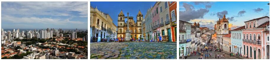
Cityscape
With the parallel narrow streets in the lower town and the chessboard-like streets in the upper town as well as the many baroque churches, Salvador shows in large parts still colonial-era urban architecture. The cathedral was built as a Jesuit church in 1657–72; Facade with flat pilasters; magnificent sacristy (18th century). According to aristmarketing, the church of the São Francisco Monastery is a major work of the Brazilian Baroque (1708–48); Decorated with gilded carvings and elaborate coffered ceiling, carved altars (including altar São Pedro Alcântara); painting in the cloister and plinth with blue and white azulejos (18th century). The facade of the Church of the Third Order of the Franciscans (São Francisco da Penitência; 1703-10) is built in the Churrigueresque style. The monastery church of Nossa Senhora do Carmo (today’s building in 1709) has ceiling paintings from the 19th century. The monastery and church of Santa Teresa (17th century) house the Museum of Sacred Art. The old town, threatened by decay, is a UNESCO World Heritage Site.
History
Salvador was founded in 1549 and was the capital of Portuguese America until 1763. A navigational base between Portugal and Goa, Salvador soon became an export port for sugar and tobacco that were grown around All Saints Bay. The intensive sugar cane cultivation during the colonial period necessitated extensive imports of African slaves, who found the city to be the most important transshipment point for South and Central America.
TERRITORY: HYDROGRAPHY
Hydrographically, the country is included in the network of the two major South American rivers, the Amazon River (to which 56% of the territory belongs) and the Paraná (approx. 10%); the remainder reaches the Atlantic via rivers that descend directly from the highlands to the coast, the largest of which is the São Francisco (river diversion works began in 2007 with the aim of bringing water to the arid zone of the northern sertão -West). From the Brazilian territory the rivers Purus, Madeira (which, however, draws from the Andean slopes), tributary to the Amazon River – which is entirely navigable and has a width of several kilometers – Tapajós, Xingu; the Tocantins (with the tributary Araguaia), which descends from the plateaus, has only its mouth in common with the Amazon River. They mostly have a mature profile, although sometimes their course is broken by rapids; some get bogged down in more or less large amphibious depressions (pantanais), such as the Xingu River in Mato Grosso. All are strongly affected by seasonal variations in rainfall, contributing significantly to the particular water regime of the Amazon River, characterized by flood phases that give rise to extensive flooding in lateral bands forming the so-called varzea. The Paraná develops the highest part of its basin on the Brazilian highlands; its eastern watershed runs here on the marginal greenhouses, not far from the Atlantic coast, from which draw important tributaries (such as the Paranaíba, the Rio Grande, the Iguaçu) which descend towards the West overcoming the escarpments of the planaltos with a series of waterfalls and cataracts between which the grandiose ones of Iguaçu. Arriving in the most depressed part of its basin, already outside Brazil, the river receives Paraguay, which has its sources in the Mato Grosso plateau; at the base of this a marked depression gives rise to an extensive pantanal, which is all part of Brazilian territory. The most important of the rivers that belong entirely to Brazil is the São Francisco, which flows in a wide furrow, with rounded profiles, between the coastal and inland ranges; it is not very rich in water, since its basin extends into the arid Northeast.Considerable length also reaches the Parnaíba, which drains the entire northern slope of the plateau, while the coastal rivers have a short course, given the rather steep morphology of the continental slope, but abundant flow.