Territorially, Brazil occupies just under half of the entire subcontinent; its coasts, which have a development of 7491 km, represent most of the South American Atlantic coastal contour; the interior has artificial boundaries which broadly correspond to the limits of Portuguese penetration. The internal borders, which measure 15,719 km, were then definitively fixed after the independence of the neighboring states. Brazil, therefore, is the first in South America by extension and number of residents and one of the largest in the world; it can be considered at the same time a Third World country, “developing”, industrialized or post-industrialized. Almost 30 times the size of Italy, a power of this magnitude, however, fails to control its enormous territory satisfactorily; moreover, the State has not yet managed, either with direct intervention or with liberalization, to rebalance the development conditions of the various regions. In the first decade of the 21st century, however, Brazil seems to have reached the basic conditions to promote an effective development model. The awareness of a strong and original national identity, of a rich and substantially unitary culture, despite the history of a population made up of different components, is a factor that could be of great importance in building a possible successful future. Compared to the other states of Latin America, in fact, Brazil stands out for its peculiar human component, Amerindians, Africans and Europeans, also following the Portuguese colonization.
TERRITORY: MORPHOLOGY
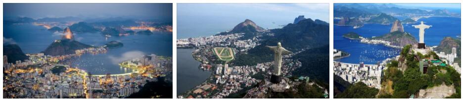
According to areacodesexplorer, the territory of Brazil has its structural foundations in three elements that are the basis of South America itself: the Guayana massif, the Brazilian plateau and the intervening Amazonian depression. The two orographic elements represent the archaeozoic structures of the subcontinent and emerge for large stretches: basically they are peneplanes from which granite massifs emerge that dominate ancient surfaces where metamorphic rocks prevail (gneiss, mica schists, quartzites). However, they are partially covered by Paleozoic and Mesozoic sediments (with a prevalence of sandstone) and by lava expansions: these sedimentary formations are mainly extended on the Brazilian plateau, while they only marginally affect the Guayana massif. As for the Amazonian depression, it has an archaeozoic substratum covered by sedimentary blankets, since the sea covered the region for long periods, up to the entire Pliocene. Pliocene formations are also found in the land facing the Atlantic. The morphology of the country depends on the different geological structures. The Guayana massif consists of a low plateau (the average is about 500 m) surmounted by granite mountains which, on the border with Venezuela, slightly exceed 3000 m (Pico da Neblina, 3014 m, the highest peak in the country). The highlands are morphologically more varied. They extend from the Atlantic coast to the great internal continental depressions of the Amazon and Paraná, divided between them by the Mato Grosso plateau which continues to the W in the penepians preceding the Andes. Generally, for these plateaus we speak of planaltos, but their shapes are different. There is no shortage of tabular structures (chapadas) that end with typical cuestas escarpmentsand are made up of both sedimentary and volcanic formations; in other cases there are flat or undulating surfaces dominated by residual crystalline outcrops. Taken as a whole, the plateaus have a characteristic asymmetry, that is, they are inclined towards the interior, ending at the E with a raised edge: here there are well-marked and equally oriented serras, such as the Serra do Mar, the Serra da Mantiqueira, the Serra do Paranapiacaba and the Serra do Espinhaço, which reach an average of 2000 m and reach their maximum height in the Pico da Bandeira (2897 m). These mountains, which represent the edge of the subcontinent, are mainly made up of granite rocks and closely dominate the coast. In some cases the relief ends directly on the sea, giving rise to a rocky and varied coastal contour, with inlets that have their magnificent example in the bay of Guanabara (or Rio de Janeiro), dominated by the morros, granite hills with a characteristic pan di sugar; in other cases the escarpment ends on short coastal plains (restingas) between which often open lagoons (lagoas) closed by sand bars: the largest is the Lagoa dos Patos (lagoon of the Anitre), 300 km long. The coastal plains are naturally broad on the northern side, where the Amazonian depression begins, morphologically represented by a flat territory bordered by the slopes of the Guayana massif to the N and by the chapadasof the Brazilian plateau and Mato Grosso to S. The whole central part where the Amazon River flows is made up of alluvial deposits; for the rest the Cenozoic sedimentary soils predominate which then give way, around the Guayanense massif and the Brazilian plateau, to the crystalline penepian or to the Paleozoic formations. In the innermost part, the Amazonian depression is bounded by the penepiano of Mato Grosso, an archaeozoic region no more than 500 m high, which continues towards W in the Chapada dos Parecis, northern edge of the Paraguay-Paraná basin, only partially included in the Brazilian territory.